


Les Assions du 27/08/2024

VANDERPUTTENMi
User GUIDE
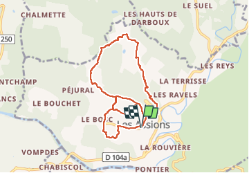

Length
9.5 km

Max alt
319 m

Uphill gradient
283 m
Km-Effort
13.3 km

Min alt
168 m

Downhill gradient
283 m
Boucle
Yes
Creation date :
2024-08-27 06:26:39.16
Updated on :
2024-08-27 13:05:56.283
3h00
Difficulty : Difficult

FREE GPS app for hiking
 SityTrail
IGN / Geographical institutes
SityTrail Plus
The world is yours!
About
Trail Walking of 9.5 km to be discovered at Auvergne-Rhône-Alpes, Ardèche, Les Assions. This trail is proposed by VANDERPUTTENMi.
Photos


Positioning
Country:
France
Region :
Auvergne-Rhône-Alpes
Department/Province :
Ardèche
Municipality :
Les Assions
Location:
Unknown
Start:(Dec)
Start:(UTM)
593418 ; 4919319 (31T) N.
Comments